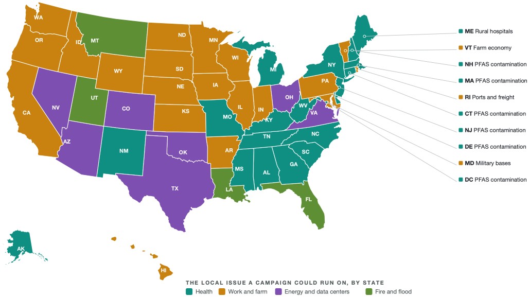
Ask what decides the midterms and you get a national answer: the economy, immigration. Ask what sits within reach of a voter’s house and the answer, in thirteen states, is a hospital. Four of those thirteen hold some of the most contested Senate and Governor races of 2026.
The United States, September 2026. Each state is colored by the family of the campaign issue running furthest above its national level there. Alaska and Hawaii are insets at their own scale.
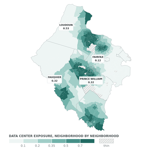
Northern Virginia. One census block group each, roughly 1,500 people, shaded by data center exposure from zero to one. Loudoun reads 0.53 against Fairfax at 0.12. Under 250 residents is hatched.
We score 239,780 American neighborhoods, covering all 331 million people, on how exposed each is to the 25 issues a House, Senate or Governor campaign could run on: a closing rural hospital, a data center, a contaminated water supply, a port, a pipeline, a farm economy. Then we ask which issue runs furthest above its national level in each state. In more states than any other the answer is the hospital. Rural hospitals are the most distinctive local issue in thirteen states.
Two big kitchen-table issues, housing and hospitals, stand out in different places.
States where housing costs stand out tend to be states where rural hospitals do not (a correlation of minus 0.49 across the fifty states and DC, minus 0.47 without DC). Housing exposure is the higher of the two almost everywhere, Georgia included. A single national cost-of-living message will fit one group of states better than the other.
Two more patterns deserve attention. Data centers are the newest local issue in the country and already lead in Nevada, Arizona, Virginia and Oklahoma, a fight about electricity bills and land as much as technology. PFAS contamination leads in six states and the District of Columbia, from New Hampshire south through the mid-Atlantic.
None of this is really a state-level story. Zoom to the neighborhood and the same issue divides places that share a ballot. In Northern Virginia, data center exposure runs at 0.53 in Loudoun and 0.12 in Fairfax, a four to one gap between neighbors in one media market. In Georgia, rural hospital exposure averages 0.09 across Fulton. South of Macon it is all or nothing: 58% of neighborhoods score exactly zero, where a hospital is still open, and 29% score above 0.48, more than five times the Fulton average.
But a message written for the state average is written for a place that does not exist.
What this is. The Persuadable Gap is a read on the voters campaigns are actually chasing, from Causal and PharosGraph. It is a diagnostic, not a forecast. We never say who will win. We say what a campaign’s plan is built for, and where the ground it is built on varies.
How it is built. PharosGraph’s neighborhood layer, covering 239,780 US census block groups and 331,449,281 people. The layer carries 50 local issues; this edition ranks the 25 a House, Senate or Governor campaign could plausibly run on. For each we estimate how exposed a neighborhood is, from how close it sits to the things that make the issue real: a hospital, a plant, a port, a contaminated site. These are estimates, not survey responses, and not anything anyone told us. No voter file is used anywhere in this piece. An issue is called a state’s most distinctive one only when it runs furthest above its national level there and its average exposure clears 0.12, so a rare issue cannot win on a large ratio alone. Because the measure tracks proximity to the hospital itself rather than how rural a county is, suburban counties can score near their state average: Gwinnett 0.18 and Cobb 0.17 against Georgia’s 0.21. Results are reported only in aggregate. Data center locations from the IM3 Open Source Data Center Atlas (Mongird, Vernon, Burleyson, Akdemir & Rice, 2026, Pacific Northwest National Laboratory, doi.org/10.57931/3017294, ODbL 1.0, derived from OpenStreetMap contributors) and Compute Atlas by Edward Kubiak, CC BY 4.0.
The Persuadable Gap · Causal and PharosGraph